

NEW DELHI, October 29, 2026: The Ministry of Jal Shakti has launched Punah Bharan, a mobile application designed to help identify suitable locations for replenishing underground water reserves using maps and scientific data. The platform allows users to identify potential groundwater recharge zones within a radius of up to three kilometres and explore the types of water-conservation structures that may be appropriate for those locations.
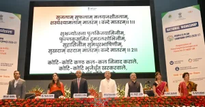
The application, launched by Union Jal Shakti Minister C.R. Paatil on Wednesday, October 28, aims to make groundwater conservation planning more location-specific. Instead of relying only on broad assessments of an area, the system uses information about rainfall, groundwater levels, land slope and drainage patterns to help determine where artificial recharge measures could be suitable.
Groundwater recharge occurs when water seeps into the ground and replenishes underground layers of soil, sand and rock that hold groundwater. Although rainfall naturally replenishes these reserves, some water flows away over the surface rather than entering the ground. Artificial recharge structures are designed to help more water infiltrate into suitable underground formations.
The challenge is that not every location is equally suitable for such structures. Rainfall patterns, terrain, underground water availability and the movement of surface water can vary considerably, even between nearby areas. A conservation structure built without considering these conditions may not deliver the expected recharge benefits.
Punah Bharan is intended to address this planning challenge by bringing several types of geographical and groundwater information together. According to the ministry, the mobile application can identify potential artificial recharge zones within a radial distance of up to three kilometres and help users explore suitable structures based on local conditions.
The three-kilometre distance refers to the geographical area that the application can examine around a location. It does not describe how deep groundwater lies underground or how far water will travel after a recharge structure is built.
The system also includes a web portal providing village-level Artificial Recharge Structure (ARS) zonation maps. These maps help planners distinguish locations that may be suitable for groundwater recharge from those where different conservation measures may be needed.
The portal provides Geographic Information System (GIS) tools and thematic layers. GIS technology allows different kinds of geographical information to be viewed and analysed together on a map. A thematic layer displays a particular characteristic of an area, such as rainfall, terrain or groundwater conditions.
For instance, rainfall data helps establish how much water an area receives, while slope and drainage information indicate how water is likely to move across the landscape. Groundwater levels show the position of underground water, and groundwater yield provides information about the capacity of underground formations to supply water.
Considering these factors together can help planners assess whether a location has potential for recharge and which type of intervention may be appropriate. The ministry describes the platform as a tool for identifying potential sites, rather than a system that guarantees successful groundwater replenishment.
The application has been developed by the Bhaskaracharya National Institute for Space Applications and Geo-informatics (BISAG-N), a government scientific institution specialising in geospatial technology, in collaboration with the National Water Mission under the Ministry of Jal Shakti’s Department of Water Resources, River Development and Ganga Rejuvenation.
The launch comes against the backdrop of continuing pressure on groundwater resources in several parts of India. According to the Central Ground Water Board’s 2025 assessment, the country had an estimated annual groundwater recharge of 448.52 billion cubic metres, while annual groundwater extraction stood at 247.22 billion cubic metres.
Although groundwater extraction at the national level was below the estimated extractable resource, the situation varied considerably across regions. Of the 6,762 assessment units examined nationwide, 730 were classified as over-exploited, meaning groundwater withdrawal exceeded the annually extractable groundwater resource. These units accounted for approximately 10.8% of the total.
This uneven distribution explains why groundwater planning cannot rely on national averages alone. Some locations face greater pressure on underground water reserves than others, while the suitability of recharge structures also depends on local geographical and geological conditions.
The Central Ground Water Board previously prepared the Master Plan for Artificial Recharge to Groundwater–2020 in consultation with states and Union Territories. The plan envisages approximately 1.42 crore rainwater-harvesting and artificial recharge structures, with the potential to harness about 185 billion cubic metres of rainwater. Punah Bharan introduces a more location-focused digital planning tool, although the ministry has not specified whether it will be formally integrated with projects under the master plan.
For local water-conservation planning, the practical value of such a tool lies in helping identify promising locations before detailed project decisions are made. However, a location appearing suitable on a digital map does not by itself establish that a particular structure should be constructed there. Site-specific technical assessment and appropriate design remain important considerations.
The ministry’s launch announcement did not specify the application’s public download arrangements, the extent of its geographical coverage or whether any locations identified through the platform have already been developed into completed recharge projects. It also did not provide measured results showing improvements in groundwater levels attributable to the new application.
Punah Bharan therefore represents a new planning resource rather than a completed groundwater conservation intervention. Its practical contribution will depend on how the mapped information is used to select, design and implement recharge measures suited to local conditions.
Read also : India’s telephone connections rise to 136.79 crore: why the total includes more than mobile phones